When our Sumo
left the gate of Bharat Sevashram Sangha, Haridwar, whole city was asleep. Late
October sun was due in his fresh day shift, but we set in our voyage. A small
tea break at Hrishikesh and we continued to cross Narendranagar, Tehri, Dharasu
one by one to reach Uttarkashi (3800ft), the District Head Quarter, by the
confluence of Asiganga and Bhagirathi. Uttarkashi has been described as
“Baranabata” in the Skandapurana and Hiuen Tsang mentioned it as “Bramhapura”.
Some people believe that the “ Jatugriha” of the Mahabharata was built here.
The city is also famous for Nehru Institute of Mountaineering. After collecting
the permit for the trek, from DFO office, we moved on and reached Gagotri
(9907ft), our base camp, at around 4 pm. Gorkha general Amar Singh Thapa built
the famous Gangotri temple in 18th century, later the Maharana of Jaipur
reconstructed it. Amar Singh appointed the
“Panda”s of Mukhwa, a village 25 from Gangotri, as the priest of the
temple and gifted them the entire forest between these two places. Every year,
the temple closes on Diwali and reopens at Akshay Tritiya or Akha Teej( mid
May). During this period, the idol of Ganges is worshiped at Mukhwa.
Famous explorer
and travel writer, Late Umaprasad Mukhopadhaya once wrote, “the vehicle of
civilization snatched away the innocence of the hill areas of India”. We
realized this helplessly at Gangotri, in our attempts to collect porters and
guide for our expedition. As soon as we got off our car, a violent mob of
agents, subagents, touts started to attack us like an army of ants, every one
trying to hijack us from the others. As the number of trekkers per day now has
been restricted by the forest dept. to protect the Gangotri glacier from being
overcrowded with irresponsible tourists, the touts have to fight more among
them for their catch. At last, a local doctor rescued us and helped a lot to
get things properly arranged.
Next morning, we
left our hotel and first day of the trek started in search of the origin of
river Bhagirathi. A steep stair like route, cemented with raw boulders, behind
the Ganga temple welcomed us. Such climb at the very first hour of the first
day trek is more than enough to demoralise the trekkers to a large extent,
especially those who are first time in high Himalayas. However, after that
stair like steps, the road is quite comfortable; steepness is acceptable, iron
fencing on the right side, along the gorge of Bhagirathi ensure a feeling of
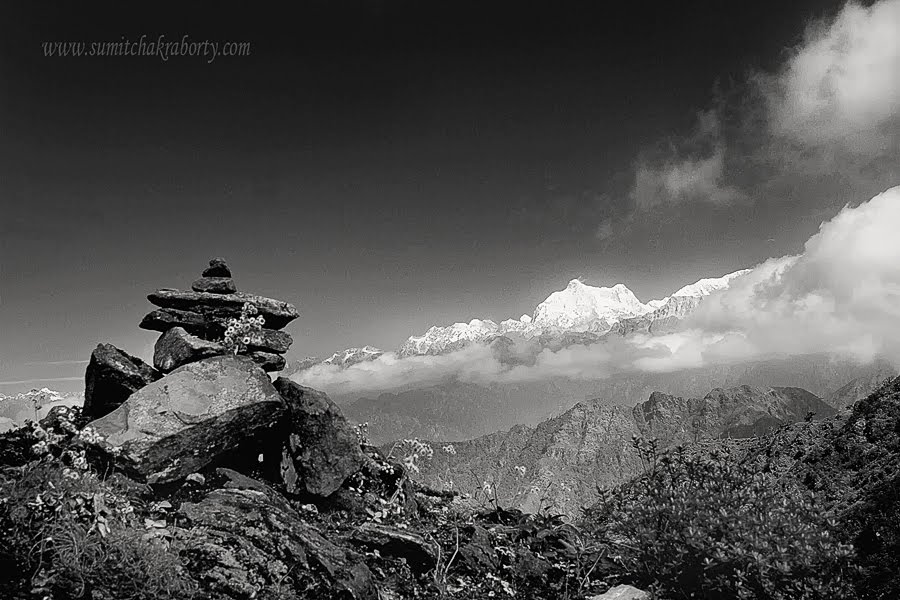
safety in mind. Glorious Sudarshan peak (21151ft) in the North and river
Bhagirathi on the right absorbs all the fatigue and inspires to move on. After
few minutes, we reached the forest check post, team leader Puspendu completed
the formalities and we marched again. A non-stop trek for almost an hour
brought us to Devgarh where Devganga meets Bhagirathi. To honor the suggestion
of having the breakfast by youngest member Sourav, the packets of biscuit and
dry fruits brought out from the sac. Balbir, our porter, flamed a small stove
behind a large boulder to make coffee. We didn’t stop at Chirbasa (11830ft), 9
km from Gangotri, and continued our journey as for the first time in this route
we got a sight of Bhagirathi Group of Peaks (22295ft, 21157ft, 20962ft), one of
the most eye catching peak cluster of Garhwal Himalayas. Strong wind started to
blow, temperature dropped a lot and we were in front of a landslide zone, from
where large boulders were wallowing down along the muddy surface due to strong
wind. I was a bit hesitant to move forward, but our guide Atar Singh Panwar
helped the whole group to cross the risky zone safely. The red flags of the
famous “Lalbaba Ashram” caught my sight and I realized that our day’s trek is
almost done. When we reached “Bhujbasa” (12440ft), enough light was still there
to pitch the tents near the Ashram. The name was derived from “ Bhuj” tree,
whose thin, white bark once used to write Sanskrit hymns, long before the
discovery of papers, but now the entire area is treeless, barren.
The third morning became a bit frustrating
when three members, who were first time in such trek, informed that they are
having nausea, headache and vomiting tendency, couldn’t sleep in night and
declared that they can’t trek up to Tapovan. Puspendu accepted that, because
the real hard trek actually starts from Goumukh, the entire route is over
dangerous glacier and last few km is steep climb through loose boulder zone. An
unfit and unwilling member can put the whole team into deep trouble. But how
can we all abandon our dream to reach Tapovan? All the members including the
guide were summoned for a team meeting with hot coffee mug and the extract of
the meet- Atar Singh will arrange three mules for the sick members, they, after
visiting Goumukh will return back to Gangotri and wait till the rest of the
team returns back from Tapovan.We packed up quickly and started our second
day’s trek. It was chilling cold outside, the grass tips were frosted, everyone
was considering sunlight as the most desirable and precious gift, but Mother
Nature maintained her own routine.
Sourav was
walking with me then. He asked about the mythological background of the region.
So I shared whatever I read before the trek. According to the Purana, Lord
Shiva once, on request of the other deities, started to sing. But none, other
than Lord Vishnu could realize the song. Spellbound Vishnu melted in water and
Lord Brahma received and held it in his ‘Kamandalu’ (ascetic’s bowl),
which became river Ganges.
After around one km trek I noticed a signboard
by Geological Survey of India indicating “ Snout position in 1935”. The present
position of the snout is 30°65' N and 79°9' E. According to the geologists, the
snout once was extended up to Goumukh, but now has been retreated almost 19 km.
We could see the snout from quite a long distance, but I couldn’t find any
resemblance between the shape of the snout and that of a cow’s mouth (Gou =
Cow, Mukh = mouth), as described in tons of Indian literary creations since the
Vedic era. Some people believe that the snout had the shape like a cow’s mouth
long ago, but the retreat and self-reconstruction of the glacier has changed it
to the present shape. Another group of experts believe that snout never had
such shape, the hold a bit different view regarding the nomenclature and the view
of this school is highly philosophic. They opine, ‘Gou’ means ‘Dharitri’ or
earth, as the Ganges or Bhagirathi is the chief contributor of the vast fertile
land of Indian subcontinent, the origin of Bhagirathi is also the origin of
Indian agriculture and prosperity. So the root of Indian ‘Dharitri’ is hidden
in the origin of Bhagirathi, I.e., Goumukh is basically the origin of Indian
landscape or Indian civilization.
 |
| Goumukh an Bhagirathi group of peaks. |
Watching the
snout at Goumukh (12760ft) from a close proximity created a strange feeling.
The mesmerizing Bhagirathi peaks appeared as a crown of the dark glacier snout,
from where Bhagirathi River comes out into the daylight through a narrow
channel. But the huge ice walls and the cracking sound of large ice blocks from
those walls surely generate a feeling of admiration, mixed with fear.
Though most of
the travel stories, available today, describes Goumukh as the origin of The
Ganges, the fact is quite different. River Mandakini originates from”
Chorabarital” or Gandhisarovar at the foothills of Kedarnath, which is
considered as the abode of Lord Shiva. River Aloknanda originates from
Badrinath, Kingdom of Lord Vishnu. These two rivers merge at Rudraprayag and
the combined flow continues Southward journey as Aloknanda, which meets Bhagirathi,
originated from Goumukh of Gangotri region (realm of Lord Brahma), at
Devaprayag. The combination gets the new name
“ The Ganges”. So, the origin of Ganges is Devprayag, Goumkh should be
treated as the origin of Bhagirathi.
A very small halt
for the documentation photography n and then we are again into the open
glacier. Gangotri glacier (26km), longest of the Garhwal region and second
longest in Indian Himalayas (1st is Siachen, 70km) has to be traversed to reach
Tapovan from Goumukh. But actually this region is the playground of lots of
other glaciers in addition to Gangotri glacier, like Raktvarn (15.9km), Kirti
(15.9km), Chaturangi (22.45km, red, white, blue and yellow these four colours
can be seen here, hence the name), Sweta, Matri, Khalipet or Bhukhapet etc.
Actually Khalipet is a tributary of Chaturangi glacier. There is an interesting
story behind this funny name. During the first survey and land measurement
under the supervision of Gordon Osmastone, a Major in the British Army, one day
the workers forgot to carry their ration to uphill, from the village. Osmastone
decided to pack up the work get down to the camp at lower altitude and
instructed accordingly. But the workers completed the survey ignoring their
life risk. As the survey had been done in empty stomach, hence the name
Khalipet or Bhukhapet.
The first
eye-catching phenomenon during the diagonal crossing of the Gangotri glacier is
the dripping of icy water through the crisscross of innumerable crevasses that
enrich the flow of river Bhagirathi. The dirt, boulders on the glacier bed some
times make it difficult to recognise the separately from rocks. When fresh snow
falls on such boulders, a horizontal mark is developed along the crevasse. This
is known as veined structure, which helps to estimate the aged of the glacier
like the annual growth ring of the tree. This is quite clearly visible in this
region.
In the mean time,
a slow but non stop steady gradual ascent had brought us to such a part of the
glacier that we got an excellent view of Bhagirathi group, Mt. Shivling
(21466ft), Matri (22045ft), Kharchakund (21753ft) etc. peaks. Atar Singh drew
our attention towards a small green patch at the foot of Mt. Shivling, near the
junction of Kirti and Gangotri glaciers as our destination, Tapovan. Few red
flags decorated the place, but the route, he showed, to reach there, made most
of us to take rest with an open mouth and hands on an achy waist. A very steep,
narrow and dusty climb of about 500ft was waiting for us. Having no alternative,
we started. But the dust and small loose pebbles made the task more difficult.
As any advance member tries to climb, a mini dust storm makes the man behind
almost blind and he has to save his head from the flurry of stones as well.
Most annoyingly there is no such point in the entire climb where one could take
rest to normalise breath if panting occurs. We were maintaining gap between two
successive trekkers to avoid such dust and stones. But that was not enough;
even the mouth became full of sand within few minutes. Such hard trek since the
morning, without proper food made me extremely exhausted. In addition to this,
last drop of water, we carried from Bhujbasa, had been consumed long ago. I
felt my tongue, throat rustling like dry sandpapers. No sooner I crawled up the
last few meters and released the sac from back, I started vomiting like hell
and lost the energy to move a single step further. I lay down on the soft grass
carpet of Tapovan. Don’t know how long laid there in nearly unconscious state,
a porter arranged a bucket of water from the nearby river Amarganga and
sprinkled on me. The cold touch of sparkling water on face and neck helped a
lot to recover, I slowly moved towards the already pitched tent, took lots of
black tea and then embraced the warmth of sleeping bag at around 8 pm after
having dinner with rice, daal and neutrila.
Our day at
Tapovan started pleasantly. I felt totally fresh having no symptoms of altitude
sickness and previous day’s fatigue. Getting out from the tent with the camera,
my eyes stuck to Mt Shivling and Mt Meru (21885ft) side by side. Day’s first
light was about to kiss the snow capped mountains. A pink glow as if,
indicating; be ready with camera, the drama is about to start. Within few
minutes the tip of Shivling became red, then nonpersistent orange, golden,
yellow in quick succession and finally eye dazzling shiny white. It was such a
mesmerizing heavenly feeling that none of our ten-member group talked or moved
in a span of more than fifteen minutes.
 |
| Mount Shivling at Tapovan |
With a cup of hot chocolate, I
occupied top of a boulder, as my throne, facing Shivling. Suddenly my brain
recalled a jocular fact, I read elsewhere while preparing for this trek. Due to
close resemblance in shape with Mt. Matterhorn of Alps, the western experts assigned
the sobriquet “ Matterhorn of India” to Mt. Shivling. But when Indian
mountaineering activity became adult, Indian mountain lovers started to
organise expeditions to the Himalayas independently, they lodged a serious
objection to such epithet. They opined as Shivling (21466ft) is much higher
than Matterhorn (14760ft), the reverse is acceptable, I.e., Matterhorn should
be called as “Shivling of Switzerland”.
From my boulder seat, I could see a smaller blackish peak, adjacent to
the main peak of Shivling, which is known as baby Shivling. Through the mid of
the whole valley Amarganga, the only source of water here, flows with chilled
water and ice pieces. A small walk towards Northeast led to a viewpoint from
where we had a magnificent view of Basuki (22285ft) and Kirtistambh (20430ft).
Atar Singh showed me another green patch on the far end of Gangotri glacier, at
the foot of Bhagirathi peaks and indicated as Nandanban, another trekkers’
paradise.
Spending the first half of
the day in exploring the valley, we started descending from Tapovan. Though
this time nobody suffered from panting or breathing trouble, but the task
became more tricky and risky than previous day’s climbing. The situation became
worse due to terrible wind. Eyes, nostrils, even mouth till the throat became
filled with sand. Puspendu’s cap having 2-3 summersaults in air flew southward,
out of sight. Suddenly Suvendu slipped off loose pebbles, lost his balance,
tumbled down badly and making our hearts almost miss a beat, narrowly escaped
from a bottomless crevasse. Apart from ankle and knee injury and a minor cut on
left eyebrow, he was intact, but victory over death in such a nail biting
finish was not powerful enough to overcome the trauma. He became numb, couldn’t
believe that he is still alive and took time to respond normally. His
belongings quickly became divided in our sac and two porters helped him to
cross the remaining part of the glacier. The team leader couldn’t afford a
break to allow him a proper rest before Goumukh. Around 5 we reached Chirbasa
again. Suvendu was having problem with his injured ankle. Naturally our speed
decreased a lot. So we decided to pitch tent near the forest bungalow and
celebrated our eventful trek by watching the dreamscapes created by the dying
light on the Bhagirathi top.
 |
| Mount Shivling and Mount Meru |
next morning we reached Gangotri within 9 and met the three members who returned from Goumukh. After breakfast, took a refreshing bath in the ice cold water of the river after four days and spend the day in total relaxing mood.